


NHC Graphical Outlook Archive
|
« Earliest Available ‹ Earlier Later › Latest Available » |
| Eastern Pacific | Atlantic |
|
|
(mouse over shaded areas for details; click on shaded areas or disturbance numbers to switch views) |
Tropical Weather Outlook Text
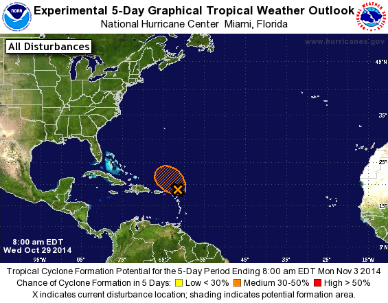
TROPICAL WEATHER OUTLOOK
NWS NATIONAL HURRICANE CENTER MIAMI FL
800 AM EDT WED OCT 29 2014

For the North Atlantic...Caribbean Sea and the Gulf of Mexico:

1. A trough of low pressure extending from near the northern Leeward
Islands northeastward over the Atlantic for a few hundred miles is
producing a large area of disorganized showers and thunderstorms.
Upper-level winds are currently marginally conducive, and some
development of this disturbance is possible during the next day or
so while it moves west-northwestward to northwestward at 10 to 15
mph.  After that time, conditions are forecast to become unfavorable
for tropical cyclone formation.
* Formation chance through 48 hours...medium...30 percent.
* Formation chance through 5 days...medium...30 percent.

Forecaster Brown
List of Atlantic Outlooks (May 2023 - present)
List of East Pacific Outlooks (May 2023 - present)
List of Central Pacific Outlooks (May 2023 - present)
List of Atlantic Outlooks (July 2014 - April 2023)
List of East Pacific Outlooks (July 2014 - April 2023)
List of Central Pacific Outlooks (June 2019 - April 2023)
List of Atlantic Outlooks (June 2009 - June 2014)
List of East Pacific Outlooks (June 2009 - June 2014)