


NHC Graphical Outlook Archive
|
« Earliest Available ‹ Earlier Later › Latest Available » |
| Eastern Pacific | Atlantic |
|
|
(mouse over shaded areas for details; click on shaded areas or disturbance numbers to switch views) |
Tropical Weather Outlook Text
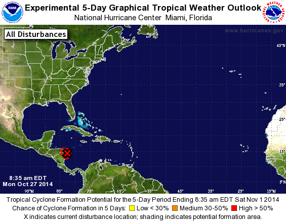
SPECIAL TROPICAL WEATHER OUTLOOK
NWS NATIONAL HURRICANE CENTER MIAMI FL
835 AM EDT MON OCT 27 2014

For the North Atlantic...Caribbean Sea and the Gulf of Mexico:

Special outlook to describe increased organization of low pressure
system over the northwestern Caribbean Sea.

1. Updated: The small low pressure system, the remnants of Tropical
Depression Nine, is producing a concentrated area of thunderstorms
along and just east of the coasts of northern Nicaragua and eastern
Honduras. This system has continued to become better organized, and
satellite-derived wind data overnight indicates that this system has
tropical-storm-force winds on the west side of the circulation. As a
result, the low is being upgraded to Tropical Storm Hanna, and a
Special Advisory will be issued by 900 am EDT...1300 UTC. Tropical
storm warnings will likely be required for portions of northeastern
Nicaragua and eastern Honduras.
* Formation chance through 48 hours...high...100 percent.
* Formation chance through 5 days...high...100 percent.

Forecaster Stewart/Berg
List of Atlantic Outlooks (May 2023 - present)
List of East Pacific Outlooks (May 2023 - present)
List of Central Pacific Outlooks (May 2023 - present)
List of Atlantic Outlooks (July 2014 - April 2023)
List of East Pacific Outlooks (July 2014 - April 2023)
List of Central Pacific Outlooks (June 2019 - April 2023)
List of Atlantic Outlooks (June 2009 - June 2014)
List of East Pacific Outlooks (June 2009 - June 2014)