


NHC Graphical Outlook Archive
|
« Earliest Available ‹ Earlier Later › Latest Available » |
| Eastern Pacific | Atlantic |
|
|
(mouse over shaded areas for details; click on shaded areas or disturbance numbers to switch views) |
Tropical Weather Outlook Text
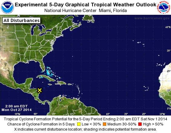
TROPICAL WEATHER OUTLOOK
NWS NATIONAL HURRICANE CENTER MIAMI FL
200 AM EDT MON OCT 27 2014

For the North Atlantic...Caribbean Sea and the Gulf of Mexico:

1. A small low pressure system, the remnants of Tropical Depression
Nine, is located over the western Caribbean Sea near Cabo Gracias
a Dios, Nicaragua.  Although showers and thunderstorms associated
with this system have increased and become more concentrated during
the past 12 hours, surface pressures are not falling.  The low is
expected to move west-southwestward or southwestward over land later
today, which should inhibit any significant development.
* Formation chance through 48 hours...low...10 percent.
* Formation chance through 5 days...low...10 percent.

Forecaster Kimberlain
List of Atlantic Outlooks (May 2023 - present)
List of East Pacific Outlooks (May 2023 - present)
List of Central Pacific Outlooks (May 2023 - present)
List of Atlantic Outlooks (July 2014 - April 2023)
List of East Pacific Outlooks (July 2014 - April 2023)
List of Central Pacific Outlooks (June 2019 - April 2023)
List of Atlantic Outlooks (June 2009 - June 2014)
List of East Pacific Outlooks (June 2009 - June 2014)