


NHC Graphical Outlook Archive
|
« Earliest Available ‹ Earlier Later › Latest Available » |
| Eastern Pacific | Atlantic |
|
|
(mouse over shaded areas for details; click on shaded areas or disturbance numbers to switch views) |
Tropical Weather Outlook Text
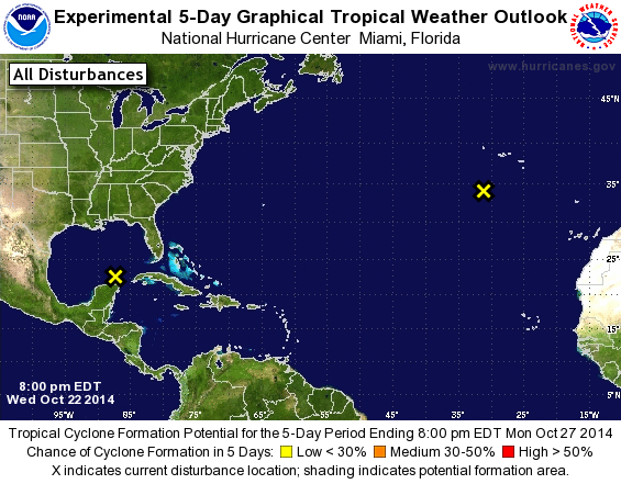
TROPICAL WEATHER OUTLOOK
NWS NATIONAL HURRICANE CENTER MIAMI FL
800 PM EDT WED OCT 22 2014

For the North Atlantic...Caribbean Sea and the Gulf of Mexico:

The National Hurricane Center is issuing advisories on Tropical
Depression Nine, located over the eastern Bay of Campeche.

1. Shower activity associated with a large non-tropical low located
over the northeastern Atlantic Ocean a few hundred miles south of
the western Azores has diminished.  Environmental conditions are
becoming less conducive, and the low is expected to weaken over the
next few days while it meanders.  Additional information on this
system can be found in High Seas Forecasts issued by Meteo France.
* Formation chance through 48 hours...low...near 0 percent.
* Formation chance through 5 days...low...near 0 percent.

2. Satellite imagery and surface observations indicate that a
non-tropical low pressure area is developing over the southeastern
Gulf of Mexico.  The low is expected to move east-northeastward,
and development into a subtropical or tropical cyclone is
unlikely due to unfavorable upper-level winds. Regardless of
development, this system is likely to cause heavy rainfall and
locally gusty winds over western Cuba, the southern portion of the
Florida Peninsula, and the Florida Keys during the next couple of
days.
* Formation chance through 48 hours...low...near 0 percent.
* Formation chance through 5 days...low...near 0 percent.

Public Advisories on Tropical Depression Nine are issued under WMO
header WTNT34 KNHC and under AWIPS header MIATCPAT4.
Forecast/Advisories on Tropical Depression Nine are issued under WMO
header WTNT24 KNHC and under AWIPS header MIATCMAT4.

High Seas Forecasts issued by Meteo France can be found under WMO
header FQNT50 LFPW.

Forecaster Beven
List of Atlantic Outlooks (May 2023 - present)
List of East Pacific Outlooks (May 2023 - present)
List of Central Pacific Outlooks (May 2023 - present)
List of Atlantic Outlooks (July 2014 - April 2023)
List of East Pacific Outlooks (July 2014 - April 2023)
List of Central Pacific Outlooks (June 2019 - April 2023)
List of Atlantic Outlooks (June 2009 - June 2014)
List of East Pacific Outlooks (June 2009 - June 2014)