


NHC Graphical Outlook Archive
|
« Earliest Available ‹ Earlier Later › Latest Available » |
| Eastern Pacific | Atlantic |
|
|
(mouse over shaded areas for details; click on shaded areas or disturbance numbers to switch views) |
Tropical Weather Outlook Text
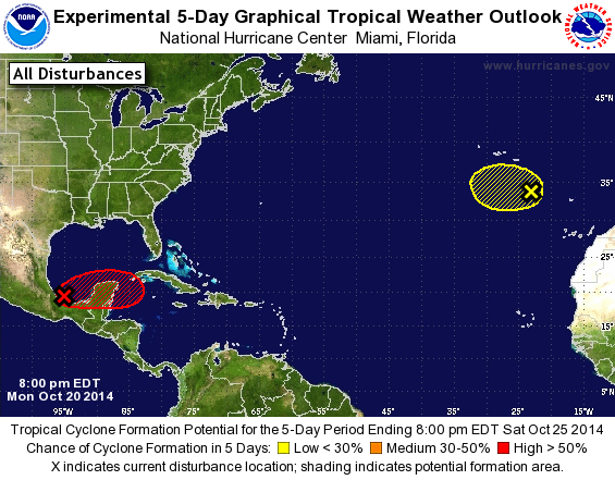
TROPICAL WEATHER OUTLOOK
NWS NATIONAL HURRICANE CENTER MIAMI FL
800 PM EDT MON OCT 20 2014

For the North Atlantic...Caribbean Sea and the Gulf of Mexico:

1. Showers and thunderstorms associated with an area of low pressure
located over the southwestern Bay of Campeche have changed little
in organization since this afternoon.  This system has the potential
to become a tropical cyclone during the next couple of days while it
moves slowly eastward across the southern Bay of Campeche. Later
in the week, the low is forecast to interact and possibly merge
with a frontal system over the southeastern Gulf of Mexico or
northwestern Caribbean Sea.  An Air Force Reserve reconnaissance
aircraft is scheduled to investigate the disturbance tomorrow
afternoon, if necessary. Interests in the Yucatan Peninsula should
monitor the progress of this system.
* Formation chance through 48 hours...medium...50 percent.
* Formation chance through 5 days...high...60 percent.

2. A large non-tropical low is located over the far eastern Atlantic
Ocean a few hundred miles southeast of the Azores. This system is
producing winds to gale-force and could gradually acquire some
subtropical characteristics during the next day or so while
it moves slowly westward.  Upper-level winds are forecast to become
less conducive for subtropical or tropical cyclone formation by late
Wednesday and development after that time is becoming less likely.
Additional information on this system can be found in High Seas
Forecasts issued by Meteo France.
* Formation chance through 48 hours...low...10 percent.
* Formation chance through 5 days...low...20 percent.

High Seas Forecasts issued by Meteo France can be found under WMO
header FQNT50 LFPW.

Forecaster Brown
List of Atlantic Outlooks (May 2023 - present)
List of East Pacific Outlooks (May 2023 - present)
List of Central Pacific Outlooks (May 2023 - present)
List of Atlantic Outlooks (July 2014 - April 2023)
List of East Pacific Outlooks (July 2014 - April 2023)
List of Central Pacific Outlooks (June 2019 - April 2023)
List of Atlantic Outlooks (June 2009 - June 2014)
List of East Pacific Outlooks (June 2009 - June 2014)