


NHC Graphical Outlook Archive
|
« Earliest Available ‹ Earlier Later › Latest Available » |
| Eastern Pacific | Atlantic |
|
|
(mouse over shaded areas for details; click on shaded areas or disturbance numbers to switch views) |
Tropical Weather Outlook Text
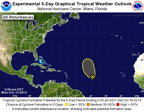
TROPICAL WEATHER OUTLOOK
NWS NATIONAL HURRICANE CENTER MIAMI FL
200 PM EDT MON OCT 13 2014

For the North Atlantic...Caribbean Sea and the Gulf of Mexico:

The National Hurricane Center is issuing advisories on Tropical
Storm Fay, located several hundred miles east-northeast of Bermuda,
and on Tropical Storm Gonzalo, located over the northern Leeward
Islands.

1. A broad area of low pressure located a little more than one
thousand miles east of the Lesser Antilles is producing
disorganized showers and thunderstorms.  Development, if any, of
this disturbance should be slow to occur while it moves slowly
northwestward.
* Formation chance through 48 hours...low...10 percent.
* Formation chance through 5 days...low...20 percent.

Forecaster Cangialosi
List of Atlantic Outlooks (May 2023 - present)
List of East Pacific Outlooks (May 2023 - present)
List of Central Pacific Outlooks (May 2023 - present)
List of Atlantic Outlooks (July 2014 - April 2023)
List of East Pacific Outlooks (July 2014 - April 2023)
List of Central Pacific Outlooks (June 2019 - April 2023)
List of Atlantic Outlooks (June 2009 - June 2014)
List of East Pacific Outlooks (June 2009 - June 2014)