


NHC Graphical Outlook Archive
|
« Earliest Available ‹ Earlier Later › Latest Available » |
| Eastern Pacific | Atlantic |
|
|
(mouse over shaded areas for details; click on shaded areas or disturbance numbers to switch views) |
Tropical Weather Outlook Text
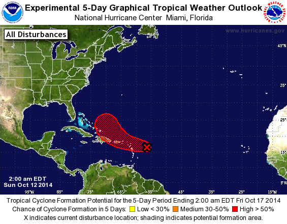
TROPICAL WEATHER OUTLOOK
NWS NATIONAL HURRICANE CENTER MIAMI FL
200 AM EDT SUN OCT 12 2014

For the North Atlantic...Caribbean Sea and the Gulf of Mexico:

The National Hurricane Center is issuing advisories on Tropical
Storm Fay, located just south of Bermuda.

1. Cloudiness and thunderstorms associated with a small low pressure
area located a few hundred miles east of the Leeward Islands
continue to show signs of organization. Although dry air may hamper
development, the overall environment is expected to be generally
conducive, and a tropical depression could form during the next day
or so.  The low is forecast to move westward at around 10 mph, and
interests from the Leeward Islands and Puerto Rico to Hispaniola and
the southeastern Bahamas should monitor its progress. An Air Force
Reserve Hurricane Hunter aircraft is scheduled to investigate this
disturbance this afternoon, if necessary. Regardless of development,
areas of heavy rains and gusty winds are expected to move across the
Leeward Islands starting later today.
* Formation chance through 48 hours...medium...50 percent.
* Formation chance through 5 days...high...60 percent.

Forecaster Brown
List of Atlantic Outlooks (May 2023 - present)
List of East Pacific Outlooks (May 2023 - present)
List of Central Pacific Outlooks (May 2023 - present)
List of Atlantic Outlooks (July 2014 - April 2023)
List of East Pacific Outlooks (July 2014 - April 2023)
List of Central Pacific Outlooks (June 2019 - April 2023)
List of Atlantic Outlooks (June 2009 - June 2014)
List of East Pacific Outlooks (June 2009 - June 2014)