


NHC Graphical Outlook Archive
|
« Earliest Available ‹ Earlier Later › Latest Available » |
| Eastern Pacific | Atlantic |
|
|
(mouse over shaded areas for details; click on shaded areas or disturbance numbers to switch views) |
Tropical Weather Outlook Text
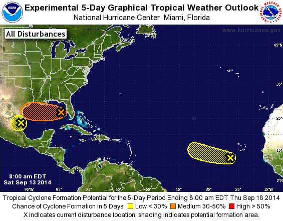
TROPICAL WEATHER OUTLOOK
NWS NATIONAL HURRICANE CENTER MIAMI FL
800 AM EDT SAT SEP 13 2014

For the North Atlantic...Caribbean Sea and the Gulf of Mexico:

The National Hurricane Center is issuing advisories on Tropical
Storm Edouard, located about 1100 miles east-northeast of the
northern Leeward Islands.

1. The area of low pressure that was over Florida yesterday is now
located over the southeastern Gulf of Mexico. Shower activity
has not become any better organized, and upper-level winds are not
favorable for significant development as the system moves generally
westward during the next few days. The Air Force Reserve
Hurricane Hunter aircraft scheduled for today is likely to be
canceled. Locally heavy rains associated with the low will continue
over portions of southern Florida and the Florida Keys through
today.
* Formation chance through 48 hours...low...20 percent.
* Formation chance through 5 days...medium...30 percent.

2. Shower activity associated with a tropical wave located southwest of
the Cape Verde Islands has become a little less organized this
morning. Some development of this system is still possible
before it moves westward or west-northwestward at around 10 mph into
an area unfavorable for tropical cyclone formation.
* Formation chance through 48 hours...low...20 percent.
* Formation chance through 5 days...low...20 percent.

3. A broad area of low pressure associated with a tropical wave over
the western Gulf of Mexico is gradually moving inland over
northeastern Mexico, and additional development is not anticipated.
Locally heavy rains and gusty winds are likely to continue
over portions of eastern Mexico and extreme southern Texas today.
* Formation chance through 48 hours...low...near 0 percent.
* Formation chance through 5 days...low...near 0 percent.

Forecaster Avila
List of Atlantic Outlooks (May 2023 - present)
List of East Pacific Outlooks (May 2023 - present)
List of Central Pacific Outlooks (May 2023 - present)
List of Atlantic Outlooks (July 2014 - April 2023)
List of East Pacific Outlooks (July 2014 - April 2023)
List of Central Pacific Outlooks (June 2019 - April 2023)
List of Atlantic Outlooks (June 2009 - June 2014)
List of East Pacific Outlooks (June 2009 - June 2014)