


NHC Graphical Outlook Archive
|
« Earliest Available ‹ Earlier Later › Latest Available » |
| Eastern Pacific | Atlantic |
|
|
(mouse over shaded areas for details; click on shaded areas or disturbance numbers to switch views) |
Tropical Weather Outlook Text
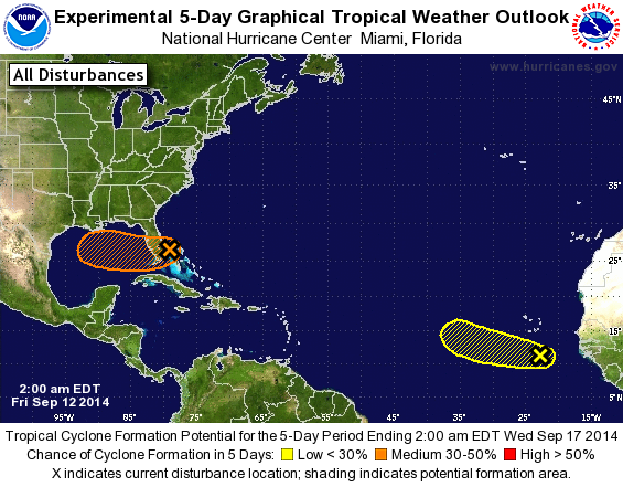
TROPICAL WEATHER OUTLOOK
NWS NATIONAL HURRICANE CENTER MIAMI FL
200 AM EDT FRI SEP 12 2014

For the North Atlantic...Caribbean Sea and the Gulf of Mexico:

The National Hurricane Center is issuing advisories on recently
upgraded Tropical Storm Edouard, located about a thousand miles west
of the Cape Verde Islands.

1. Shower and thunderstorm activity is currently limited in association
with an area of low pressure located about 70 miles east-northeast
of West Palm Beach, Florida. Strong upper-level winds and
interaction with the Florida peninsula will likely inhibit
development of this system today while it moves slowly west-
southwestward across the southern Florida peninsula. Once the low
moves over the southeastern Gulf of Mexico conditions could become
a little more conducive for tropical cyclone formation over the
weekend while the system moves westward at around 10 mph. Regardless
of development, this low will bring locally heavy rains to portions
of southern Florida and the Florida Keys through today.
* Formation chance through 48 hours...low...20 percent.
* Formation chance through 5 days...medium...40 percent.

2. A tropical wave located south of the Cape Verde Islands is producing
disorganized shower and thunderstorm activity. Any development of
this system is expected to be slow to occur during the next couple
of days while it moves westward to west-northwestward at around 10
mph. After that time, conditions over the central tropical Atlantic
are expected to be unfavorable for development.
* Formation chance through 48 hours...low...10 percent.
* Formation chance through 5 days...low...10 percent.

Public Advisories on Tropical Storm Edouard are issued under WMO
header WTNT31 KNHC and under AWIPS header MIATCPAT1.
Forecast/Advisories on Edouard are issued under WMO header WTNT21
KNHC and under AWIPS header MIATCMAT1.

Forecaster Brennan
List of Atlantic Outlooks (May 2023 - present)
List of East Pacific Outlooks (May 2023 - present)
List of Central Pacific Outlooks (May 2023 - present)
List of Atlantic Outlooks (July 2014 - April 2023)
List of East Pacific Outlooks (July 2014 - April 2023)
List of Central Pacific Outlooks (June 2019 - April 2023)
List of Atlantic Outlooks (June 2009 - June 2014)
List of East Pacific Outlooks (June 2009 - June 2014)