


NHC Graphical Outlook Archive
|
« Earliest Available ‹ Earlier Later › Latest Available » |
| Eastern Pacific | Atlantic |
|
|
(mouse over shaded areas for details; click on shaded areas or disturbance numbers to switch views) |
Tropical Weather Outlook Text
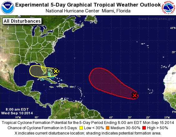
TROPICAL WEATHER OUTLOOK
NWS NATIONAL HURRICANE CENTER MIAMI FL
800 AM EDT WED SEP 10 2014

For the North Atlantic...Caribbean Sea and the Gulf of Mexico:

1. A broad area of low pressure is located about 600 miles
west-southwest of the Cape Verde Islands, with the associated shower
and thunderstorm activity remaining disorganized. While tropical
cyclone formation is not anticipated today, environmental conditions
could become somewhat more favorable for development by later in the
week while the low moves toward the west-northwest and northwest at
about 15 mph over the open Atlantic.
* Formation chance through 48 hours...low...20 percent.
* Formation chance through 5 days...high...70 percent.

2. Disorganized cloudiness and showers over the Bahamas and the
adjacent Atlantic are associated with a weak surface trough
interacting with an upper-level low. Development, if any, of this
system is expected to be very slow to occur while it moves generally
westward at 5 to 10 mph during the next few days.
* Formation chance through 48 hours...low...10 percent.
* Formation chance through 5 days...low...20 percent.

Forecaster Beven
List of Atlantic Outlooks (May 2023 - present)
List of East Pacific Outlooks (May 2023 - present)
List of Central Pacific Outlooks (May 2023 - present)
List of Atlantic Outlooks (July 2014 - April 2023)
List of East Pacific Outlooks (July 2014 - April 2023)
List of Central Pacific Outlooks (June 2019 - April 2023)
List of Atlantic Outlooks (June 2009 - June 2014)
List of East Pacific Outlooks (June 2009 - June 2014)