


NHC Graphical Outlook Archive
|
« Earliest Available ‹ Earlier Later › Latest Available » |
| Eastern Pacific | Atlantic |
|
|
(mouse over shaded areas for details; click on shaded areas or disturbance numbers to switch views) |
Tropical Weather Outlook Text
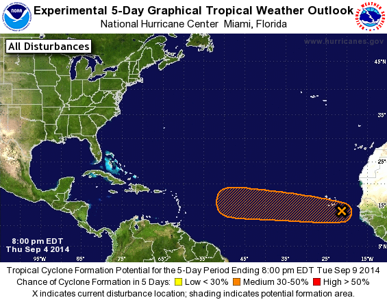
TROPICAL WEATHER OUTLOOK
NWS NATIONAL HURRICANE CENTER MIAMI FL
800 PM EDT THU SEP 4 2014

For the North Atlantic...Caribbean Sea and the Gulf of Mexico:

1. A tropical wave accompanied by a broad area of low pressure located
a couple hundred miles east-southeast of the Cape Verde Islands is
producing disorganized shower and thunderstorm activity. Some slow
development of this disturbance is possible over the next several
days while it moves westward at about 15 mph. Regardless of
development, this system could bring heavy rain and gusty winds in
squalls to portions of the Cape Verde Islands tonight and Friday.
* Formation chance through 48 hours...low...20 percent.
* Formation chance through 5 days...medium...30 percent.

Forecaster Brennan
List of Atlantic Outlooks (May 2023 - present)
List of East Pacific Outlooks (May 2023 - present)
List of Central Pacific Outlooks (May 2023 - present)
List of Atlantic Outlooks (July 2014 - April 2023)
List of East Pacific Outlooks (July 2014 - April 2023)
List of Central Pacific Outlooks (June 2019 - April 2023)
List of Atlantic Outlooks (June 2009 - June 2014)
List of East Pacific Outlooks (June 2009 - June 2014)