


NHC Graphical Outlook Archive
|
« Earliest Available ‹ Earlier Later › Latest Available » |
| Eastern Pacific | Atlantic |
|
|
(mouse over shaded areas for details; click on shaded areas or disturbance numbers to switch views) |
Tropical Weather Outlook Text
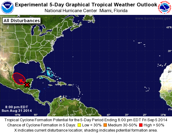
TROPICAL WEATHER OUTLOOK
NWS NATIONAL HURRICANE CENTER MIAMI FL
800 PM EDT SUN AUG 31 2014

For the North Atlantic...Caribbean Sea and the Gulf of Mexico:

1. Satellite and surface data indicate that a broad area of low
pressure has formed in association with a tropical wave moving
across the Yucatan Peninsula. The low is forecast to move over the
waters of the eastern Bay of Campeche early Monday, where
environmental conditions are expected to be conducive for
development.  This system has the potential to become a tropical
depression while it moves west-northwestward at about 10 mph across
the southwestern Gulf of Mexico during the next two to three days.
* Formation chance through 48 hours...medium...50 percent.
* Formation chance through 5 days...high...60 percent.

Forecaster Brown
List of Atlantic Outlooks (May 2023 - present)
List of East Pacific Outlooks (May 2023 - present)
List of Central Pacific Outlooks (May 2023 - present)
List of Atlantic Outlooks (July 2014 - April 2023)
List of East Pacific Outlooks (July 2014 - April 2023)
List of Central Pacific Outlooks (June 2019 - April 2023)
List of Atlantic Outlooks (June 2009 - June 2014)
List of East Pacific Outlooks (June 2009 - June 2014)