


NHC Graphical Outlook Archive
|
« Earliest Available ‹ Earlier Later › Latest Available » |
| Eastern Pacific | Atlantic |
|
|
(mouse over shaded areas for details; click on shaded areas or disturbance numbers to switch views) |
Tropical Weather Outlook Text
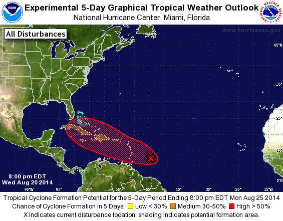
TROPICAL WEATHER OUTLOOK
NWS NATIONAL HURRICANE CENTER MIAMI FL
800 PM EDT WED AUG 20 2014

For the North Atlantic...Caribbean Sea and the Gulf of Mexico:

1. Shower and thunderstorm activity associated with an elongated area
of low pressure located several hundred miles east of the Windward
Islands is slowly becoming better organized.  Additional development
is possible during the next day or two, and a tropical depression
could form as the system moves west-northwestward at 10 to 15 mph
across the Lesser Antilles and into the Caribbean Sea. After that
time, land interaction could limit development potential over the
weekend.  Regardless of tropical cyclone formation, gusty winds and
heavy rainfall are possible across portions of the Lesser Antilles,
Puerto Rico, and the Virgin Islands on Thursday night and Friday.
Interests in those islands should closely monitor the progress of
this system.  An Air Force Reserve Hurricane Hunter aircraft is
scheduled to investigate the low tomorrow afternoon, if necessary.
* Formation chance through 48 hours...medium...50 percent.
* Formation chance through 5 days...high...70 percent.

Forecaster Beven
List of Atlantic Outlooks (May 2023 - present)
List of East Pacific Outlooks (May 2023 - present)
List of Central Pacific Outlooks (May 2023 - present)
List of Atlantic Outlooks (July 2014 - April 2023)
List of East Pacific Outlooks (July 2014 - April 2023)
List of Central Pacific Outlooks (June 2019 - April 2023)
List of Atlantic Outlooks (June 2009 - June 2014)
List of East Pacific Outlooks (June 2009 - June 2014)