


NHC Graphical Outlook Archive
|
« Earliest Available ‹ Earlier Later › Latest Available » |
| Eastern Pacific | Atlantic |
|
|
(mouse over shaded areas for details; click on shaded areas or disturbance numbers to switch views) |
Tropical Weather Outlook Text
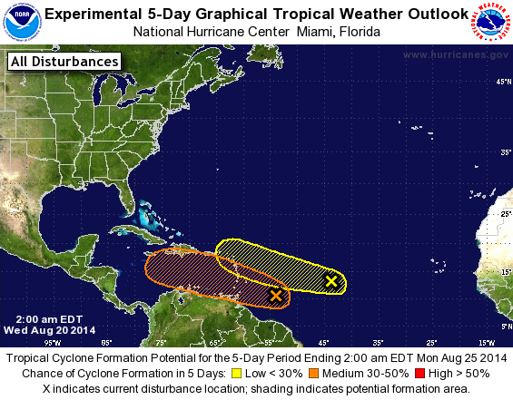
TROPICAL WEATHER OUTLOOK
NWS NATIONAL HURRICANE CENTER MIAMI FL
200 AM EDT WED AUG 20 2014

For the North Atlantic...Caribbean Sea and the Gulf of Mexico:

1. Shower activity is currently limited in association with an
elongated area of low pressure located several hundred miles east of
the southern Windward Islands.  Gradual development of this system
is possible during the next few days while it moves
west-northwestward at 10 to 15 mph across the Lesser Antilles and
into the Caribbean Sea.  Interests in the Lesser Antilles should
closely monitor the progress of this system.
* Formation chance through 48 hours...medium...30 percent.
* Formation chance through 5 days...medium...50 percent.

2. A tropical wave located about 1000 miles east of the Lesser
Antilles continues to produce disorganized showers and
thunderstorms.  Development of this system, if any, should be slow
to occur during the next several days while it moves toward the
west-northwest at about 10 mph.
* Formation chance through 48 hours...low...10 percent.
* Formation chance through 5 days...low...20 percent.

Forecaster Cangialosi
List of Atlantic Outlooks (May 2023 - present)
List of East Pacific Outlooks (May 2023 - present)
List of Central Pacific Outlooks (May 2023 - present)
List of Atlantic Outlooks (July 2014 - April 2023)
List of East Pacific Outlooks (July 2014 - April 2023)
List of Central Pacific Outlooks (June 2019 - April 2023)
List of Atlantic Outlooks (June 2009 - June 2014)
List of East Pacific Outlooks (June 2009 - June 2014)