


NHC Graphical Outlook Archive
|
« Earliest Available ‹ Earlier Later › Latest Available » |
| Eastern Pacific | Atlantic |
|
|
(mouse over shaded areas for details; click on shaded areas or disturbance numbers to switch views) |
Tropical Weather Outlook Text
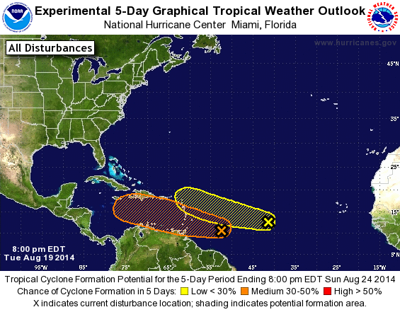
TROPICAL WEATHER OUTLOOK
NWS NATIONAL HURRICANE CENTER MIAMI FL
800 PM EDT TUE AUG 19 2014

For the North Atlantic...Caribbean Sea and the Gulf of Mexico:

1. Disorganized shower and thunderstorm activity continues in
association with an elongated area of low pressure that extends from
the northeastern coast of South America into the central tropical
Atlantic. Environmental conditions are forecast to be more conducive
for gradual development of this system during the next few days as
it approaches the Lesser Antilles and moves into the Caribbean Sea.
* Formation chance through 48 hours...medium...30 percent.
* Formation chance through 5 days...medium...50 percent.

2. A tropical wave located about midway between the west coast of
Africa and the Lesser Antilles is producing limited and disorganized
shower activity. Some slow development of this system is possible
over the next several days while it moves toward the west-northwest
at about 10 mph.
* Formation chance through 48 hours...low...10 percent.
* Formation chance through 5 days...low...20 percent.

Forecaster Beven
List of Atlantic Outlooks (May 2023 - present)
List of East Pacific Outlooks (May 2023 - present)
List of Central Pacific Outlooks (May 2023 - present)
List of Atlantic Outlooks (July 2014 - April 2023)
List of East Pacific Outlooks (July 2014 - April 2023)
List of Central Pacific Outlooks (June 2019 - April 2023)
List of Atlantic Outlooks (June 2009 - June 2014)
List of East Pacific Outlooks (June 2009 - June 2014)