


NHC Graphical Outlook Archive
|
« Earliest Available ‹ Earlier Later › Latest Available » |
| Eastern Pacific | Atlantic |
|
|
(mouse over shaded areas for details; click on shaded areas or disturbance numbers to switch views) |
Tropical Weather Outlook Text
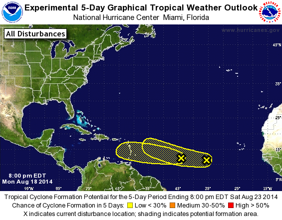
TROPICAL WEATHER OUTLOOK
NWS NATIONAL HURRICANE CENTER MIAMI FL
800 PM EDT MON AUG 18 2014

For the North Atlantic...Caribbean Sea and the Gulf of Mexico:

1. Shower activity associated with a weak and elongated area of low
pressure centered about 1000 miles east of the Lesser Antilles
remains disorganized. Environmental conditions are not expected to
be favorable for significant development over the next few days
while the system moves to the west or west-northwest at 10 to 15
mph.
* Formation chance through 48 hours...low...near 0 percent.
* Formation chance through 5 days...low...10 percent.

2. An area of disturbed weather over the central tropical Atlantic
Ocean about midway between Africa and the Lesser Antilles is
associated with a tropical wave.  Any development of this system is
expected to be slow to occur over the next several days while it
moves to the west-northwest at about 10 mph.
* Formation chance through 48 hours...low...10 percent.
* Formation chance through 5 days...low...20 percent.

Forecaster Blake
List of Atlantic Outlooks (May 2023 - present)
List of East Pacific Outlooks (May 2023 - present)
List of Central Pacific Outlooks (May 2023 - present)
List of Atlantic Outlooks (July 2014 - April 2023)
List of East Pacific Outlooks (July 2014 - April 2023)
List of Central Pacific Outlooks (June 2019 - April 2023)
List of Atlantic Outlooks (June 2009 - June 2014)
List of East Pacific Outlooks (June 2009 - June 2014)