


NHC Graphical Outlook Archive
|
« Earliest Available ‹ Earlier Later › Latest Available » |
| Eastern Pacific | Atlantic |
|
|
(mouse over shaded areas for details; click on shaded areas or disturbance numbers to switch views) |
Tropical Weather Outlook Text
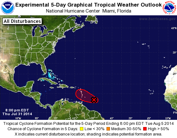
TROPICAL WEATHER OUTLOOK
NWS NATIONAL HURRICANE CENTER MIAMI FL
800 PM EDT THU JUL 31 2014

For the North Atlantic...Caribbean Sea and the Gulf of Mexico:

1. An Air Force Reserve reconnaissance aircraft this afternoon and
evening investigated the well-defined low pressure system located
about 350 miles east-southeast of Barbados, and found surface winds
of 40 to 45 mph across the northern and eastern portions of the
circulation.  Showers and thunderstorms have increased east of the
center during the past couple of hours, and if this development
trend continues a tropical storm could form later tonight or early
Friday. Regardless of development, gale-force winds are likely to
spread across portions of the central Lesser Antilles beginning by
midday Friday.  Interests in these areas should continue to monitor
the progress of this disturbance as it moves west-northwestward near
20 mph, since watches or warnings could be required for some of
these islands later tonight or Friday.
* Formation chance through 48 hours...high...80 percent.
* Formation chance through 5 days...high...80 percent.

Forecaster Stewart
List of Atlantic Outlooks (May 2023 - present)
List of East Pacific Outlooks (May 2023 - present)
List of Central Pacific Outlooks (May 2023 - present)
List of Atlantic Outlooks (July 2014 - April 2023)
List of East Pacific Outlooks (July 2014 - April 2023)
List of Central Pacific Outlooks (June 2019 - April 2023)
List of Atlantic Outlooks (June 2009 - June 2014)
List of East Pacific Outlooks (June 2009 - June 2014)