


NHC Graphical Outlook Archive
« Earliest Available ‹ Earlier Later › Latest Available »
Place your mouse cursor over areas of interest for more information
| GIS data: .shp |
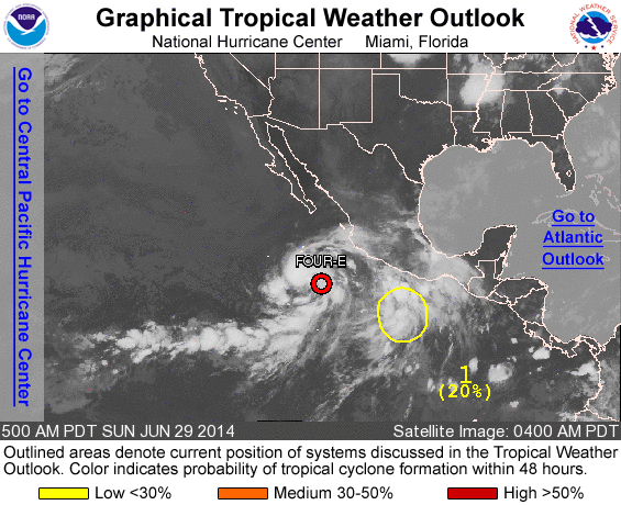
ZCZC MIATWOEP ALL
TTAA00 KNHC DDHHMM

TROPICAL WEATHER OUTLOOK
NWS NATIONAL HURRICANE CENTER MIAMI FL
500 AM PDT SUN JUN 29 2014

For the eastern North Pacific...east of 140 degrees west longitude:

The National Hurricane Center is issuing advisories on Tropical
Depression Four-E, located several hundred miles southwest of
Manzanillo, Mexico.

1. A weak area of low pressure located a few hundred miles south-
southeast of Acapulco, Mexico, continues to produce disorganized
showers and thunderstorms as it moves west-northwestward to
northwestward at around 10 mph.  The proximity of this disturbance
to Tropical Depression Four-E may limit development during the next
couple of days, but environmental conditions are expected to become
favorable for slow development after that time.
* Formation chance through 48 hours...medium...20 percent.
* Formation chance through 5 days...medium...50 percent.

Public Advisories on Tropical Depression Four-E are issued under WMO
header WTPZ34 KNHC and under AWIPS header MIATCPEP4.
Forecast/Advisories on Tropical Depression Four-E are issued under
WMO header WTPZ24 KNHC and under AWIPS header MIATCMEP4.

Forecaster Kimberlain
List of all Atlantic Outlooks
List of all East Pacific Outlooks