


NHC Graphical Outlook Archive
« Earliest Available ‹ Earlier Later › Latest Available »
Place your mouse cursor over areas of interest for more information
| GIS data: .shp |
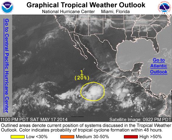
ZCZC MIATWOEP ALL
TTAA00 KNHC DDHHMM

TROPICAL WEATHER OUTLOOK
NWS NATIONAL HURRICANE CENTER MIAMI FL
1100 PM PDT SAT MAY 17 2014

For the eastern North Pacific...east of 140 degrees west longitude:

Systems with the potential to become a tropical cyclone during the
next 48 hours...

1. A broad area of low pressure located several hundred miles
southwest of Acapulco, Mexico, is producing a large area of
showers and thunderstorms.  Any development of this system should be
slow to occur during the next couple of days. After that time,
environmental conditions are expected to become unfavorable for
development.
* Formation chance through 48 hours...low...20 percent
* Formation chance through 5 days...low...20 percent

Forecaster Blake
List of all Atlantic Outlooks
List of all East Pacific Outlooks