NHC Graphical Outlook Archive (Text)
Standard version of this page
« Earliest Available ‹ Earlier Later › Latest Available »
Place your mouse cursor over areas of interest for more information
Graphical TWO atl
ZCZC MIATWOAT ALL
TTAA00 KNHC DDHHMM
TROPICAL WEATHER OUTLOOK
NWS NATIONAL HURRICANE CENTER MIAMI FL
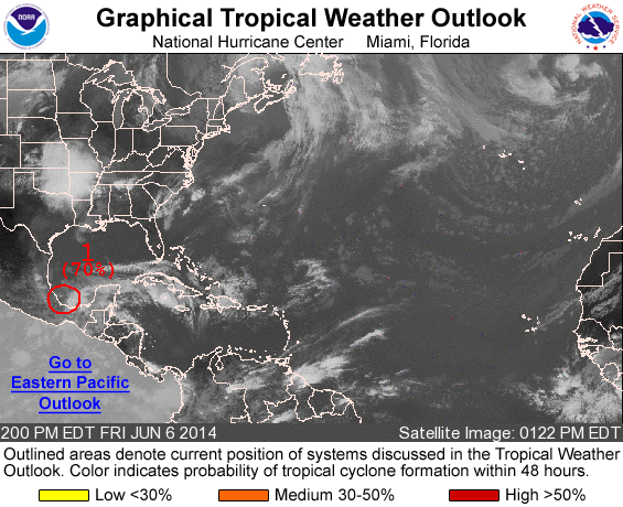
200 PM EDT FRI JUN 6 2014
For the North Atlantic...Caribbean Sea and the Gulf of Mexico:
1. Satellite imagery shows that shower and thunderstorm activity
associated with a a well-defined low pressure area located about 25
miles northeast of Vera Cruz, Mexico has diminished during the
past several hours. If thunderstorms redevelop near the center, a
tropical depression could still form before the low reaches the
coast of eastern Mexico later this evening or tonight. The Air Force
Reserve reconnaissance aircraft scheduled to investigate this system
has been delayed. Whether a tropical depression forms or not, this
disturbance could produce heavy rains, along with life-threatening
flash floods and mud slides, over portions of southeastern and
eastern Mexico during the next few days.
* Formation chance through 48 hours...high...70 percent.
* Formation chance through 5 days...high...70 percent.
Forecaster Beven
List of all Atlantic Outlooks
List of all East Pacific Outlooks