NHC Graphical Outlook Archive (Text)
Standard version of this page
« Earliest Available ‹ Earlier Later › Latest Available »
Place your mouse cursor over areas of interest for more information
Graphical TWO atl
ZCZC MIATWOAT ALL
TTAA00 KNHC DDHHMM
TROPICAL WEATHER OUTLOOK
NWS NATIONAL HURRICANE CENTER MIAMI FL
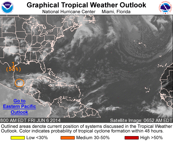
800 AM EDT FRI JUN 6 2014
For the North Atlantic...Caribbean Sea and the Gulf of Mexico:
1. Shower and thunderstorm activity associated with a low pressure
area over the southwestern Bay of Campeche has changed little in
organization overnight. Although upper-level winds are expected to
remain unfavorable for significant development, an Air Force Reserve
reconnaissance aircraft is still scheduled to investigate this
system this afternoon, if necessary. Regardless of tropical cyclone
formation, this disturbance could produce heavy rains, along with
life-threatening flash floods and mud slides, over portions of
southeastern and eastern Mexico during the next few days.
* Formation chance through 48 hours...medium...50 percent.
* Formation chance through 5 days...medium...50 percent.
Forecaster Kimberlain
List of all Atlantic Outlooks
List of all East Pacific Outlooks