


Marine Safety
Hurricanes have been the cause of many maritime disasters and unfortunately, there is no single rule of thumb that can be used by mariners to ensure safe separation from a hurricane at sea. Instead, constant monitoring of hurricane potential & continual risk analysis when used with some fundamental guidelines become the basic tools to minimize a hurricane's impact to vessels at sea or in port. Today, even as our understanding of hurricanes increases, there is still much error inherent in forecasting the movement & intensity of these systems. Through the use of a recurring risk analysis, mariners can minimize potential impacts of a hurricane encounter. Coincidental with the fact that NHC issues 4 Tropical Cyclone Forecast/Advisory Messages (TCM) per day when a system is active, the risk analysis needs to be done in conjunction with each new TCM to ensure that the sailor is evaluating the latest information to make navigation decisions. This risk analysis includes a number of extremely important factors needed to make sound decisions & ultimately remain clear of hurricanes either at sea or in-port.
History
of Regional Hurricane Tracks
There are climatologically favored regions/tracks for hurricane development/movement
in the North Atlantic. Both are important to vessels at sea or in port in order
to begin assessing risks involved during the hurricane season. Knowledge of
hurricane climatology is the first significant aids in helping mariners avoid
these systems in the North Atlantic. LEARN
MORE
Impact
of Ocean Currents & Warm Water
Certain areas in the basin support rapid intensification of hurricanes. Understanding
the contribution that warm water plays in the growth of a hurricane, it is easy
to appreciate that ocean regions with high sea-surface temperatures (greater
than 79° F or 26° C) are often dangerous locations for mariners to be
found as a hurricane threatens. Knowing local sea-surface temperatures (SST)
& location of ocean currents are also important factors for the mariner.
The two most prominent areas to possess this danger are the Gulf of Mexico &
the Gulf Stream.
A second impact that the Gulf Stream places on vessels is enhanced sea states resulting from the interaction of ocean current with hurricane wind field. Winds of tropical storm or hurricane force opposing any ocean current can quickly create very steep, short period waves making navigation through these areas extremely dangerous and difficult.
Knowledge
of Inherent Hurricane Track/Intensity Errors
Generally speaking, the smallest errors associated with hurricane track forecasts
occur while a system is moving in a general west to west-northwest track, south
of the Atlantic subtropical ridge. Conversely, the largest errors involved in
hurricane forecast tracks occur during recurvature & beyond as systems first
slow when starting to recurve, then typically accelerate northeast after recurvature.
Similarly, increased uncertainty in track forecasts often occurs when a system
is in an area of little to no environmental steering, a situation tending to
occur most often in the Western Caribbean Sea & Gulf of Mexico.
By themselves, intensity errors can be quite large through the 72 hour forecast of the TCM. These errors are accentuated when a poor intensity forecasts is combined with the average track forecast errors occasionally resulting in even worse forecasts of the radius of tropical storm force winds associated with hurricanes, particularly at the 2 to 3 day range.
Guidelines
For Avoiding Hurricanes At Sea
In order to help account for the inherent errors in hurricane forecasting, a
few guidelines should be used by the mariner in order to limit the potential
of a close encounter between ship & storm.
34
KT Rule
For vessels at sea, avoiding the 34 KT wind field of a hurricane is paramount.
34 KT is chosen as the critical value because as wind speed increases to this
speed, sea state development approaches critical levels resulting in rapidly
decreasing limits to ship maneuverability. It also deserves mention that the
state of the sea outside of the radius of 34 KT winds can also be significant
enough as to limit course & speed options available to the mariner and must
also be considered when avoiding hurricanes.
Ship
Versus Hurricane Track Analysis
In the dynamic state of moving ships & hurricanes, recurring comparison
of hurricane forecast track versus planned ship movement is mandatory. The continual
monitoring of the latest official NHC forecasts compared to current or planned
evasion options can greatly increase a mariner's confidence regarding vessel
safety.
Never
Cross The "T"
Never plan to cross the track (cross the "T") of a hurricane. Done
out of respect for the negative effects that heavy weather places on vessel
speed/handling, sudden accelerations in hurricane motion can ultimately place
a vessel in conditions not originally expected thereby resulting in disaster.
Adjustments to course & speed in order to remain clear of the danger area
in a hurricane are the most prudent navigation decisions a mariner can make
in these instances.
Forecast
Track Tendencies
Comparison of the most recent NHC forecast track with forecast tracks from the
past 24 hours can sometimes prove useful for determining a trend in the forecast
motion of a hurricane. For instance, a comparison of forecast tracks issued
every 6 hours over the last 24 hours, may show a noticeable shift right or left
(with respect to storm motion) in the forecast track of a hurricane. This information
may provide some indication as to how the forecast & actual hurricane track
are tending and provide more guidance in navigation planning for avoidance,
particularly in the 2-3 day forecast range & beyond.
Calculating
Closest Point of Approach (CPA)
The last item to complete in the at-sea risk analysis is comparison of CPA between
current & possible evasion options. Over time, increases in CPA between
vessel & hurricane based on current navigation decisions should increase
the mariner's confidence in current avoidance plans. However, decreases in CPA
should be dealt with using the utmost urgency. An immediate review of all evasion
options combined with a detailed look into the latest official forecasts/discussions
needs to be accomplished with a goal of establishing a new evasion course/speed
option to once again increase CPA from the hurricane.
Assessing
Options
Mariners must be cautioned never to leave themselves with only a single navigation
option when attempting to avoid a hurricane. Sea room to maneuver is not a significant
factor when operating in the open waters of the North Atlantic, but becomes
extremely important in the confined waters of the Western Caribbean Sea/Gulf
of Mexico. More often than not, early decisions to leave restricted maneuver
areas are the most sensible choice.
Port
Specific Risk Analysis Considerations
Vessels seeking shelter in port or considering movement toward or away from
port need to consider all the factors discussed above while acknowledging some
other factors in order to finalize their risk analysis.
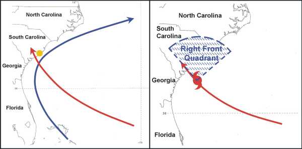
Hurricane
Approach To Port
In general, hurricanes forecast to make a perpendicular landfall tend to have
the smallest amount of FTE. Conversely, systems that are forecast to parallel
the coast, as is often noted in the Mid-Atlantic region of the United States,
tend to have larger track errors. Additionally, hurricanes that make landfall
within 50-100 NM of a particular port tend to be more destructive than those
that approach the port from over land or parallel the coast in the vicinity
of the port. Also, ports located in the right front
quadrant, based on direction of movement of hurricanes during landfall tend
to have higher winds, seas, and storm surge.
Go
& No Go Decisions To Leave Port
The decision to leave port for hurricane avoidance must be made very early.
Consideration to the latest safe departure time & likely avoidance routes
must be balanced with a number of other factors. Most important of these is
time versus distance. The risk of damage to a vessel at sea increases as the
motion of the hurricane increases towards the maximum safe speed of the vessel
attempting to leave port in advance of that system. When reviewing these time/distance
considerations, mariners must include the effects "squally weather"
associated with the rainbands in a hurricane will have on underway preparations
& movement from port. Similarly, building wind & sea conditions found
at sea, ahead of the hurricane, can also hamper vessel speed & maneuverability.
Recognizing these time/distance problems, it cannot be emphasized enough that
early decisions to leave port in attempt to avoid hurricanes are crucial. There
have been a number of recorded instances where vessels have made the right decision
to leave port in attempts to avoid hurricanes, yet were still either damaged/lost
because that decision came too late.
Berthing
& Shelter Requirements
Considerations to remain in port during hurricane passage must include an evaluation
of the amount of protection afforded by the port. The direction from which the
strongest winds are forecast to blow along with the potential for storm surge
must be factored in when deciding whether to seek haven pier side, at anchorage,
or further inland to more protected anchorage. For instance, storm surge can
pose significant problems to vessels tied pier side. Substantial rises in water
level may place a vessel, previously in a protected wind/wave regime, into an
area exposed to significantly greater winds & waves. Similarly, many port
& dock facilities, particularly in the Caribbean region are fixed. Although
sufficient to support the normally small tidal range of the region, they can
quickly become submerged when exposed to even minimal hurricane related surge.
Additionally, attention to the tying of lines is also of considerable importance.
This is because the force on a moored vessel will nearly double for every 15
knots of wind from tropical storm force (34 KT) to hurricane force (64 KT).
Therefore, a vessel tied to the pier under normal situations can quickly break
from the pier in periods of higher winds causing substantial damage to itself
or other vessels.
RELATED
WEBSITES
• NWS
VOLUNTARY OBSERVING SHIP PROGRAM
• NATIONAL
DATA BUOY CENTER
• COAST
GUARD STORM CENTER
ADDITIONAL SAFETY INFORMATION
MARINE SAFETY ACTIONS
- Review regional tropical cyclone climatology for area of expected operations.
- Obtain latest Marine Prediction Center & Tropical Prediction Center analysis/forecast charts; including surface, upper level, & Sea State (wind/wave) charts.
- Locate & plot tropical (easterly) waves, disturbances, and tropical cyclones.
- If available, examine current satellite imagery.
- Obtain latest tropical cyclone advisory messages. Plot current/ forecast positions of all active/ suspected tropical cyclone activity.
- Plot completed tropical cyclone danger area to avoid chart.
- Determine possible courses of action (at least 2) for vessel to take in order to remain clear of the Danger.
- Evaluate current/nearby port & hurricane haven locations that may be considered for tropical cyclone avoidance.
- Calculate Closest Point of Approach (CPA) to tropical cyclone for all courses of action based on latest forecast/ advisory.
- Make decision on course of action to follow and execute. Continue to closely monitor tropical cyclone's progress and review the actions listed here when new meteorological analysis & forecast information becomes available.
1-2-3 RULE OF THUMB
1 - 100 mile error radius for 24hr forecast
2 - 200 mile error radius for 48hr forecast
3 - 300 mile error radius for 72hr forecast
STEPS TO DETERMINE THE HURRICANE DANGER AREA
- Plot the initial and forecast hurricane positions on a navigation chart.
- Find the maximum radius of 34 KT winds at the initial, 24, 48, and 72 hour forecast times of the TCM.
- Apply the 1-2-3 rule to each of the radii at the 24, 48, and 72 hour forecast positions.
- Draw a circle around the hurricane initial position with radius equal to the maximum radius of 34 KT winds given in the TCM.
- Draw circles around the 24, 48, and 72 hour forecast positions of the hurricane using the respective radii found in step 3.
- Connect tangent lines to each circle constructed in steps 3 and 4 along both sides of the hurricane track.
- The area enclosed by these tangent lines is known as the danger area of the hurricane and must be avoided as a vessel attempts to navigate in the vicinity of the hurricane. VIEW THE DIAGRAM (400kb(PDF))
SIGNIFICANT ATLANTIC HURRICANE ENCOUNTERS WITH SHIPS
- Western Cuba
& Straits of Florida Oct
1644
Thirteen ships carrying 1500 people encounter the hurricane resulting in 10 ships sunk and many lives lost. - Guadeloupe,
Martinique 14-15 Aug 1666
Seventeen ships with 2000 troops under direction of the British Governor of Barbados set sail...only two are ever heard from afterwards. - Jamaica
1 Aug 1781
Over 120 vessels were driven ashore, a large number of which are destroyed. Of the vessels lost, 30 are British men of war. - Virgin Islands
13-16 Aug 1793
Reports of 28 of 42 slaves lost with the additional loss of some crew on board the BRISTOL. There are also indications of three slave-bearing vessels from Africa also lost in this hurricane. - North Carolina
& Virginia 2 Aug 1795
A fleet of eighteen Spanish ships, sailing from Havana to Spain are struck off Cape Hatteras. An undisclosed number of these ships are lost. - North Carolina
30 Oct 1862
Twenty-five Federal vessels leave Hampton Roads for the fleet about to attack Port Royal in South Carolina. The next day, fifty more vessels set sail. In the vicinity of Cape Hatteras, these vessels were all damaged with two of the steamers lost in a hurricane encounter. - The Carolinas
8-19 Aug 1899
Fifty deaths occur in shipwrecks along coastal Carolina. - The Central
Atlantic 9 Oct 1913
Immigrant ship VOLTURNO, with 657 people aboard, burst into flames in a �wild gale at sea� halfway across the Atlantic....135 lives are lost - Straits of
Florida and Gulf of Mexico 9-14 Sep 1919
Over 500 people were lost on 10 ships that were either sunk or reported missing. - New Jersey
7-8 Sep 1934
Liner MORRO CASTLE caught fire and was abandoned in poor weather preceding an approaching hurricane. 134 people died from burning, drowning and exposure. - Western Atlantic
14-15 Sep 1944
The loss of five ships and 344 deaths are attributed to this hurricane. - Gulf of Honduras
27 Oct 1998
FANTOME encounters Hurricane MITCH with the loss of the vessel along with a crew of 31.