000
AXNT20 KNHC 131004
TWDAT
Tropical Weather Discussion
NWS National Hurricane Center Miami FL
1205 UTC Mon May 13 2024
Tropical Weather Discussion for North America, Central America
Gulf of Mexico, Caribbean Sea, northern sections of South
America, and Atlantic Ocean to the African coast from the
Equator to 31N. The following information is based on satellite
imagery, weather observations, radar and meteorological analysis.
Based on 0600 UTC surface analysis and satellite imagery through
1000 UTC.
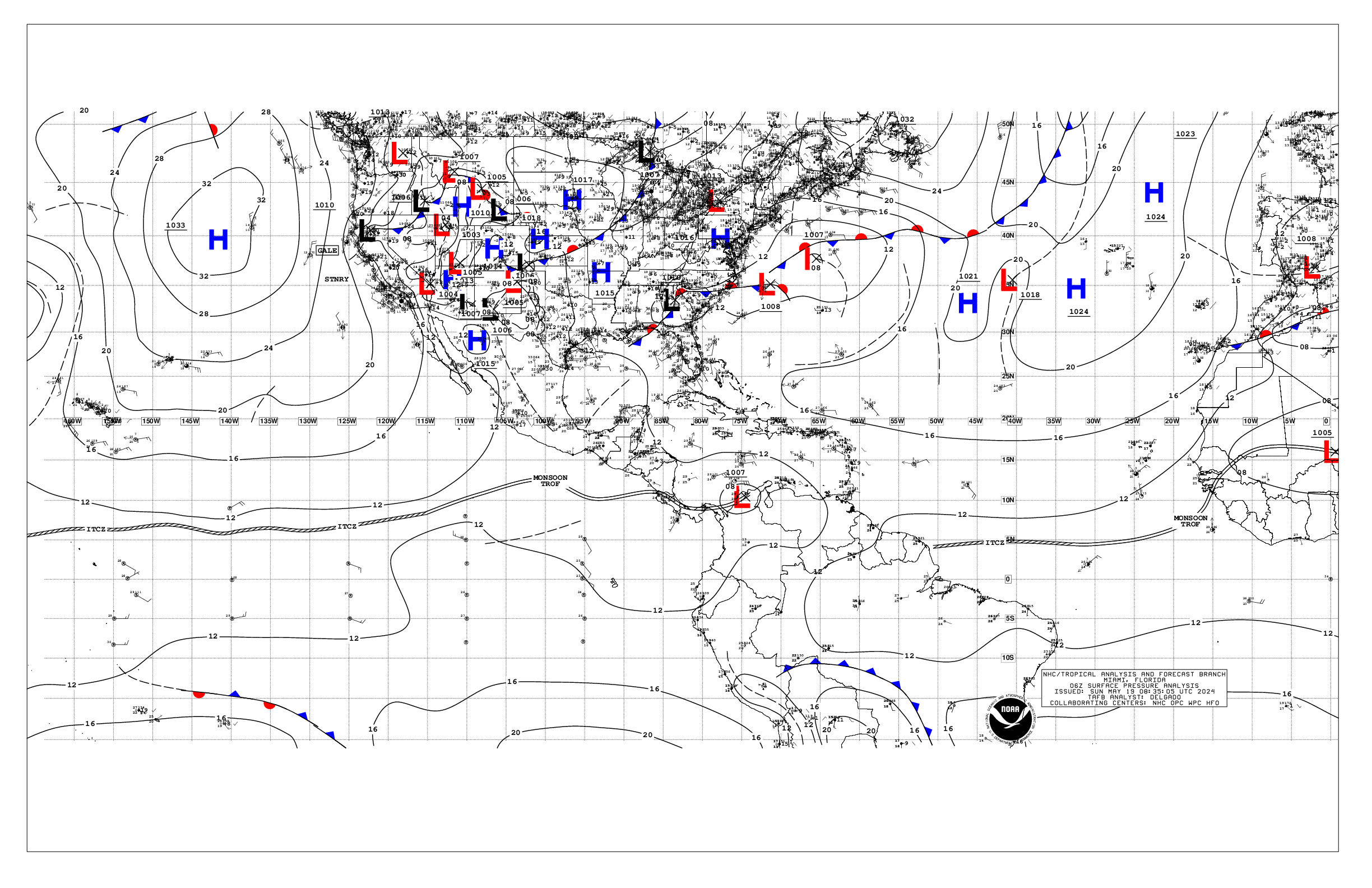
...MONSOON TROUGH/ITCZ...
The monsoon trough extends from Mauritania/Senegal border near
16N16W to 04N25W. The ITCZ continues from 04N25W to the coast of
Brazil near 02N48W. Scattered moderate convection is noted from
01N to 08N between 11W and 43W.
...GULF OF MEXICO...
Weak high pressure dominates the Gulf of Mexico. Scattered showers
and isolated thunderstorms are noted in the western Gulf. Fresh
to locally strong easterly winds are found in the central
Caribbean, with gentle to moderate E-SE winds prevailing
elsewhere west of 86W. Seas are 4 to 6 ft in this area. In the
rest of the Gulf, light to gentle winds and slight seas are
prevalent.
For the forecast, high pressure extends across the basin. An
inverted trough may develop over the western Gulf early this week
where it may linger through at least mid-week. Heavy rainfall and
thunderstorms are expected across the northern Gulf over the next
few days. Mainly moderate to fresh return flow will dominate the
basin, pulsing to strong near the Yucatan Peninsula and Yucatan
Channel. Meanwhile, haze due to agricultural fires in Mexico
continues across most of the western Gulf and Bay of Campeche.
...CARIBBEAN SEA...
A weak pressure gradient prevails across the basin, sustaining
moderate easterly trade winds over most of the basin. The
exception is the Gulf of Honduras, where strong to near gale E-SE
winds are currently pulsing with seas to 8 ft. Fresh to strong
winds are also noted in the south-central Caribbean with seas to 7
ft. Seas are slight to moderate across the rest of the basin.
Scattered moderate convection is noted in the SW Caribbean along
the monsoon trough, S of 11N.
For the forecast, high pressure over the central Atlantic will
support strong to near gale E to SE winds near the Gulf of
Honduras through most of the week. Fresh to strong winds are
expected in the south- central basin through Wed, where winds will
decrease to moderate to fresh through the later part of the week.
Seas will build through the week as a result of the increasing
winds. Gentle to moderate winds are expected elsewhere through
most of the week. Meanwhile, haze due to agricultural fires in
Central America continues across some areas of the northwestern
Caribbean.
...ATLANTIC OCEAN...
A weak cold front extends from 31N61W to 28N63W then stalls from
that point to the South Florida coast near 26N80W. A pre- frontal
trough is analyzed from 28N56W to 22N67W. Scattered moderate
convection is noted north of 20N and between 52W and 66W.
Moderate to fresh winds are noted near the front mainly north of
28N and between 58W and 68W. Seas in these waters are 4 to 6 ft.
Light to gentle winds and slight to moderate seas prevail
elsewhere west of 50W, while moderate to fresh easterly winds
prevail east of 50W.
The remainder of the tropical Atlantic is dominated by a broad
1030 mb high pressure system centered to the west of the Azores.
The pressure gradient between this ridge and relatively lower
pressures in northwest Africa result in fresh to strong northerly
winds north of 15N and east of 22W. Seas in the area described are
in the 8 to 10 ft range. Elsewhere, moderate or weaker winds and
moderate seas are prevalent.
For the forecast W of 55W, the aforementioned front will weaken
as it reaches from near 31N58W the Central Bahamas today, then
dissipating from near 27N55W to 22N65W by early Tue. High pressure
will build in its wake. Fresh to strong southerly winds and
building seas are forecast offshore N Florida by Tue ahead of
another possible cold front. That front may reach from near 31N76W
to 27N80W by early Thu, weakening and stalling from 31N69W to
near Fort Pierce, Florida by early Fri. Conditions around the
front will improve by Fri.
$$
AReinhart