ZCZC MIATWOAT ALL
TTAA00 KNHC DDHHMM
Tropical Weather Outlook
NWS National Hurricane Center Miami FL
800 AM EDT Sun Aug 16 2020
For the North Atlantic...Caribbean Sea and the Gulf of Mexico:
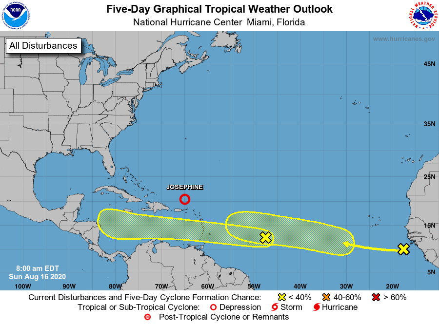
The National Hurricane Center is issuing advisories on Tropical
Storm Josephine, located a couple of hundred miles northeast of San
Juan, Puerto Rico. The National Hurricane Center has issued the
last advisory on Post-Tropical Cyclone Kyle, located several hundred
miles southwest of Cape Race, Newfoundland.
1. A fast-moving tropical wave located about 850 miles east of the
Windward Islands is producing a small area of disorganized showers
and thunderstorms. This system is expected to move westward at
about 20 mph during the next few days, and that fast speed is likely
to limit development while the system approaches the Windward and
southern Leeward Islands today and Monday and moves across the
eastern Caribbean Sea on Tuesday. After that time, the system is
expected to move more slowly westward across the central and western
Caribbean Sea, and upper-level winds could be conducive for
development during the middle to latter part of this week.
* Formation chance through 48 hours...low...10 percent.
* Formation chance through 5 days...low...30 percent.
2. Another tropical wave located just west of the coast of Africa is
producing a large area of cloudiness and showers. This wave is
forecast to move westward at 15 to 20 mph during the next few days,
and some development will be possible by the middle to latter part
of the week as environmental conditions become more conducive while
the system is over the central tropical Atlantic.
* Formation chance through 48 hours...low...near 0 percent.
* Formation chance through 5 days...low...30 percent.
Forecaster Brown