


NHC Graphical Outlook Archive
« Earliest Available ‹ Earlier Later › Latest Available »
Place your mouse cursor over areas of interest for more information
| GIS data: .shp |
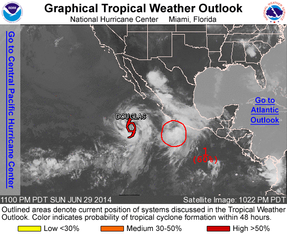
ZCZC MIATWOEP ALL
TTAA00 KNHC DDHHMM

TROPICAL WEATHER OUTLOOK
NWS NATIONAL HURRICANE CENTER MIAMI FL
1100 PM PDT SUN JUN 29 2014

For the eastern North Pacific...east of 140 degrees west longitude:

The National Hurricane Center is issuing advisories on recently
upgraded Tropical Storm Douglas, located several hundred miles
south-southwest of the southern tip of the Baja California peninsula
of Mexico.

1. Showers and thunderstorms associated with an area of low pressure
located about 240 miles south-southeast of Manzanillo, Mexico,
continue to show signs of organization.  Although upper-level winds
are not particularly conducive for additional development, only a
slight increase in organization could result in the formation of a
tropical cyclone during the next day or so while the system moves
west-northwestward at about 10 mph.
* Formation chance through 48 hours...high...60 percent.
* Formation chance through 5 days...high...60 percent.

Forecaster Pasch
List of all Atlantic Outlooks
List of all East Pacific Outlooks