


NHC Graphical Outlook Archive
« Earliest Available ‹ Earlier Later › Latest Available »
Place your mouse cursor over areas of interest for more information
| GIS data: .shp |
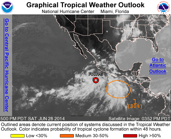
ZCZC MIATWOEP ALL
TTAA00 KNHC DDHHMM

TROPICAL WEATHER OUTLOOK
NWS NATIONAL HURRICANE CENTER MIAMI FL
500 PM PDT SAT JUN 28 2014

For the eastern North Pacific...east of 140 degrees west longitude:

The National Hurricane Center is issuing advisories on newly formed
Tropical Depression Four-E, located several hundred miles southwest
of the southwestern coast of Mexico.

1. A small area of low pressure located several hundred miles south-
southwest of the Gulf of Tehuantepec is producing disorganized
showers and thunderstorms. Some development of this system is
possible over the next few days while it moves west-northwestward or
northwestward at 10 to 15 mph.
* Formation chance through 48 hours...medium...30 percent.
* Formation chance through 5 days...medium...50 percent.

Public Advisories on Tropical Depression Four-E are issued under WMO
header WTPZ34 KNHC and under AWIPS header MIATCPEP4.
Forecast/Advisories on Tropical Depression Four-E are issued under
WMO header WTPZ24 KNHC and under AWIPS header MIATCMEP4.

Forecaster Brennan
List of all Atlantic Outlooks
List of all East Pacific Outlooks