NHC Graphical Outlook Archive (Text)
Standard version of this page
« Earliest Available ‹ Earlier Later › Latest Available »
Place your mouse cursor over areas of interest for more information
Graphical TWO atl
ZCZC MIATWOAT ALL
TTAA00 KNHC DDHHMM
TROPICAL WEATHER OUTLOOK
NWS NATIONAL HURRICANE CENTER MIAMI FL
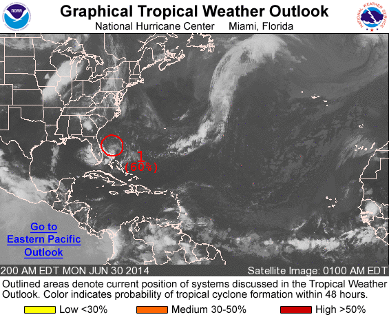
200 AM EDT MON JUN 30 2014
For the North Atlantic...Caribbean Sea and the Gulf of Mexico:
1. Shower and thunderstorm activity remains minimal in association with
a low pressure area located about 210 miles east-southeast of St.
Augustine, Florida. Environmental conditions are forecast to become
more conducive for development during the next few days and a
tropical depression is likely to form by mid-week while the system
moves slowly southwestward, then north and northeastward near the
southeastern United States coast. An Air Force Reserve
reconnaissance aircraft is scheduled to investigate the low this
afternoon, if necessary.
* Formation chance through 48 hours...high...60 percent.
* Formation chance through 5 days...high...80 percent.
Forecaster Blake
List of all Atlantic Outlooks
List of all East Pacific Outlooks