


NHC Graphical Outlook Archive
« Earliest Available ‹ Earlier Later › Latest Available »
Place your mouse cursor over areas of interest for more information
| GIS data: .shp |
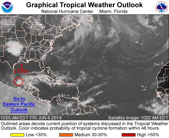
ZCZC MIATWOAT ALL
TTAA00 KNHC DDHHMM

SPECIAL TROPICAL WEATHER OUTLOOK
NWS NATIONAL HURRICANE CENTER MIAMI FL
1055 AM EDT FRI JUN 6 2014

For the North Atlantic...Caribbean Sea and the Gulf of Mexico:

1. Satellite imagery and surface observations indicate that the
area of low pressure about 40 miles east of Veracruz, Mexico, has
become a little better defined this morning as it moves slowly
west-northwestward.  However, the associated thunderstorm activity
is currently poorly organized.  A tropical depression could form
before the low reaches the coast of eastern Mexico later today or
tonight. An Air Force Reserve reconnaissance aircraft is scheduled
to investigate this system this afternoon. Whether a tropical
depression forms or not, this disturbance could produce heavy rains,
along with life-threatening flash floods and mud slides, over
portions of southeastern and eastern Mexico during the next few
days.
* Formation chance through 48 hours...medium...70 percent.
* Formation chance through 5 days...medium...70 percent.

Forecaster Beven
List of all Atlantic Outlooks
List of all East Pacific Outlooks