NHC Graphical Outlook Archive (Text)
Standard version of this page
« Earliest Available ‹ Earlier Later › Latest Available »
Place your mouse cursor over areas of interest for more information
Graphical TWO atl
ZCZC MIATWOAT ALL
TTAA00 KNHC DDHHMM
TROPICAL WEATHER OUTLOOK
NWS NATIONAL HURRICANE CENTER MIAMI FL
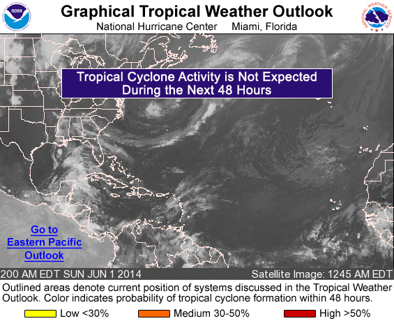
200 AM EDT SUN JUN 1 2014
For the North Atlantic...Caribbean Sea and the Gulf of Mexico:
An elongated area of low pressure located over the Bay of Campeche
extends northeastward into the south-central Gulf of Mexico.
Although shower activity is currently disorganized, some slow
development of this nearly stationary disturbance will be possible
over the next several days as environmental conditions become
marginally conducive.
* Formation chance through 48 hours...low...near 0 percent
* Formation chance through 5 days...low...20 percent
Today marks the first day of the Atlantic hurricane season, which
will run until November 30. Long-term averages for the number of
named storms, hurricanes, and major hurricanes are 12, 6, and 3,
respectively.
The list of names for 2014 is as follows:
Name Pronunciation Name Pronunciation
-------------------------------------------------------------
Arthur AR-thur Laura LOOR-ruh
Bertha BUR-thuh Marco MAR-koe
Cristoabl krees-TOH-bahl Nana NA-na
Dolly DAH-lee Omar OH-mar
Edouard eh-DWARD Paulette pawl-LET
Fay fay Rene re-NAY
Gonzalo gohn-SAH-loh Sally SAL-ee
Hanna HAN-uh Teddy TEHD-ee
Isaias ees-ah-EE-ahs Vicky VIH-kee
Josephine JOH-seh-feen Wilfred WILL-fred
Kyle KY-ull
This product, the Tropical Weather Outlook, briefly describes
significant areas of disturbed weather and their potential for
tropical cyclone formation during the next 48 hours. The issuance
times of this product are 2 AM, 8 AM, 2 AM, and 8 PM EDT. After
the change to standard time in November, the issuance times are
1 AM, 7 AM, 1 PM, and 7 PM EST.
A Special Tropical Weather Outlook will be issued to provide
updates, as necessary, in between the regularly scheduled
issuances of the Tropical Weather Outlook. Special Tropical
Weather Outlooks will be issued under the same WMO and AWIPS
headers as the regular Tropical Weather Outlooks.
A standard package of products, consisting of the Tropical Cyclone
Public Advisory, the Forecast/Advisory, the Tropical Cyclone
Discussion, and the Wind Speed Probabilities, is issued every six
hours for all ongoing tropical cyclones. In addition, a Special
Advisory package may be issued at any time to advise of
significant unexpected changes or to modify watches or warnings.
The Tropical Cyclone Update is a brief statement to inform of
significant changes in a tropical cyclone or to post or cancel
watches or warnings. It is used in lieu of or to precede the
issuance of a special advisory package. The Tropical
Cyclone Update is also used to provide a continuous flow of
information regarding the center location of a tropical cyclone
when watches or warnings are in effect and the center can be easily
tracked with land-based radar. Tropical Cyclone Updates,
which can be issued at any time, can be found under WMO header
WTNT61-65 KNHC, and under AWIPS header MIATCUAT1-5.
All National Hurricane Center text and graphical products are
available on the web at http://www.hurricanes.gov. You can also
interact with NHC on Facebook at https://www.facebook.com/NWSNHC.
Notifications are available via Twitter when select National
Hurricane Center products are issued. Information about our
Atlantic Twitter feed is available at
http://www.hurricanes.gov/twitter.php.
$$
Forecaster Stewart
NNNN
List of all Atlantic Outlooks
List of all East Pacific Outlooks