Skip Navigation Links weather.gov   
NOAA logo - Click to go to the NOAA homepage National Weather Service   NWS logo - Click to go to the NWS homepage
National Hurricane Center
Local forecast by
"City, St" or "ZIP"

 
Cyclone Forecasts
   Latest Advisory
   Past Advisories
   Audio/Podcasts
   About Advisories
Marine Forecasts
   Atlantic & E Pacific
   Gridded Marine
   About Marine
Tools & Data
   Satellite | Radar
   Analysis Tools
   Aircraft Recon
   GIS Datasets
   Data Archive
Development
   Experimental
   Research
   Forecast Accuracy
Outreach & Education
   Prepare
   Storm Surge
   About Cyclones
   Cyclone Names
   Wind Scale
   Most Extreme
   Forecast Models
   Breakpoints
   Resources
   Glossary | Acronyms
   Frequent Questions
Our Organization
   About NHC
   Mission & Vision
   Staff | Q&A
   Visitors | Virtual Tour
   Library Branch
   NCEP | Newsletter
Contact Us
   Comments
Follow the National Hurricane Cent
er on Facebook Follow the National Hurricane Center on Twitter
FirstGov.gov is the U.S. Government's official Web portal to all Federal, state and local government Web resources and services.


NHC Graphical Outlook Archive


« Earliest Available         ‹ Earlier         Later ›         Latest Available »
Place your mouse cursor over areas of interest for more information
Graphical TWO atl Click for Eastern Pacific

GIS data:  .shp
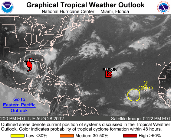
ZCZC MIATWOAT ALL TTAA00 KNHC DDHHMM

TROPICAL WEATHER OUTLOOK NWS NATIONAL HURRICANE CENTER MIAMI FL
200 PM EDT TUE AUG 28 2012

FOR THE NORTH ATLANTIC...CARIBBEAN SEA AND THE GULF OF MEXICO...

THE NATIONAL HURRICANE CENTER IS ISSUING ADVISORIES ON HURRICANE
ISAAC APPROACHING THE SOUTHEAST LOUISIANA COAST.

1. SHOWER ACTIVITY ASSOCIATED WITH AN AREA OF LOW PRESSURE...LOCATED
ABOUT 1425 MILES SOUTHWEST OF THE AZORES...HAS BECOME BETTER
ORGANIZED TODAY. A TROPICAL DEPRESSION COULD FORM AT ANY TIME TODAY
OR TONIGHT... BEFORE UPPER-LEVEL WINDS BECOME UNFAVORABLE FOR
DEVELOPMENT DURING THE NEXT DAY OR TWO. THIS SYSTEM HAS A MEDIUM
CHANCE...50 PERCENT...OF BECOMING A TROPICAL CYCLONE DURING THE
NEXT 48 HOURS AS THE LOW MOVES TOWARD THE WEST-NORTHWEST AT 10 TO
15 MPH.

2. A LARGE BUT DISORGANIZED AREA OF CLOUDINESS AND SHOWERS ASSOCIATED
WITH A TROPICAL WAVE IS LOCATED ABOUT 350 MILES WEST-SOUTHWEST OF
THE CAPE VERDE ISLANDS. ENVIRONMENTAL CONDITIONS ARE FORECAST TO
BECOME MORE CONDUCIVE FOR DEVELOPMENT OVER THE NEXT SEVERAL DAYS.
THIS SYSTEM HAS A LOW CHANCE...20 PERCENT...OF BECOMING A TROPICAL
CYCLONE DURING THE NEXT 48 HOURS AS IT MOVES WESTWARD ABOUT 15 MPH.

ELSEWHERE...TROPICAL CYCLONE FORMATION IS NOT EXPECTED DURING THE
NEXT 48 HOURS.

$$ FORECASTER AVILA


List of all Atlantic Outlooks
List of all East Pacific Outlooks


Quick Navigation Links:
Tropical Cyclone Forecasts  -  Tropical Marine Forecasts  -  Data Archive
Outreach  -  Prepare  -  About Cyclones  -  About NHC  -  Contact Us

NOAA/ National Weather Service
National Centers for Environmental Prediction
National Hurricane Center
11691 SW 17th Street
Miami, Florida 33165-2149 USA
nhcwebmaster@noaa.gov
Disclaimer
Credits
Information Quality
Glossary
Privacy Policy
Freedom of Information Act (FOIA)
About Us
Career Opportunities
Page last modified: Monday, 16-Jul-2012 19:58:38 UTC