000
AXPZ20 KNHC 180310
TWDEP
Tropical Weather Discussion
NWS National Hurricane Center Miami FL
0405 UTC Sat May 18 2024
Tropical Weather Discussion for the eastern Pacific Ocean from
03.4S to 30N, east of 120W including the Gulf of California, and
from the Equator to 30N, between 120W and 140W. The following
information is based on satellite imagery, weather observations,
radar, and meteorological analysis.
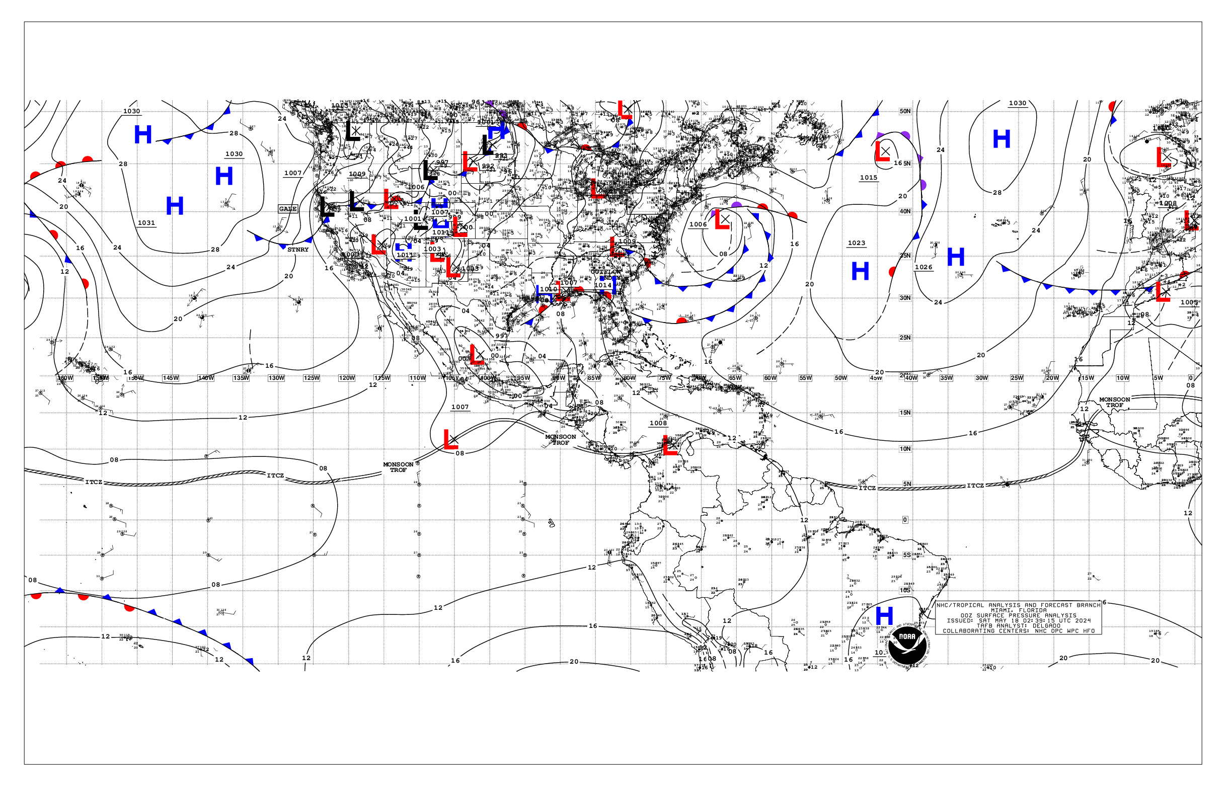
Based on 0000 UTC surface analysis and satellite imagery through
0300 UTC.
...INTERTROPICAL CONVERGENCE ZONE/MONSOON TROUGH...
The monsoon trough extends from a 1008 mb low pressure located
over northern Colombia near 10N74W to 14N97W to a 1007 mb low
pressure situated near 11N105W to 06N120W. The ITCZ then continues
from 06N120W to 06N140W. Scattered moderate and isolated strong
convection is noted from 09N to 14N between 90W and 110W.
...OFFSHORE WATERS WITHIN 250 NM OF MEXICO...
A ridge dominates the offshore forecast waters of Baja California
supporting moderate to fresh NW winds north of the Revillagigedo
Islands. Elsewhere, winds are gentle or weaker. Seas are 5 to 7
ft along the Pacific waters and 1 to 3 ft over the Gulf of
California. Reduced visibilities were noted south of S Mexico
due to agricultural fires.
For the forecast, the surface ridge over the waters west of the
Baja California peninsula along with the trough over NW Mexico
will promote fresh NW to N winds over the Pacific north of Cabo
San Lucas for the next several days. Disorganized showers and
thunderstorms continue several hundred miles to the south of the
coast of southern Mexico in association with a trough of low
pressure. Development of this system, if any, should be slow to
occur as it moves slowly westward during the next few days.
Looking ahead, large NW swell may impact the waters west of Baja
California Norte beginning on Mon.
...OFFSHORE WATERS WITHIN 250 NM OF CENTRAL AMERICA, COLOMBIA,
AND WITHIN 750 NM OF ECUADOR...
Winds are moderate or weaker across the Central American and
equatorial Pacific waters due to a weak pressure gradient over
the area. Seas are 5 to 6 ft in SW swell.
For the forecast, the monsoon trough extending along 11-12N will
help force scattered showers and isolated thunderstorms over the
Central American waters for the next couple of days. Away from
the isolated thunderstorms, winds should remain moderate or
weaker through early next week.
...REMAINDER OF THE AREA...
A ridge dominates the waters N of 15N and W of 110W. The pressure
gradient between the ridge and lower pressure along the ITCZ is
forcing moderate to fresh NE to E trades from 05N to 20N west of
120W with seas to 8 to 9 ft . A 1007 mb low pressure is along
the monsoon trough near 11N105W with fresh SW winds within 120
NM on the SE semicircle. Elsewhere, winds are moderate or weaker
Seas are 6 to 8 ft across the basin.
For the forecast, little change is expected for the tradewinds
during the next several days. While environmental conditions
appear only marginally favorable due to nearby dry air, some
development of the aforementioned low is possible during the
next day or so as it remains nearly stationary. By late this
weekend, the low is forecast to interact or merge with a second
system to its east, and further development is not expected.
Disorganized showers and thunderstorms are associated with a
trough of low pressure near 11N98W (the second system).
Development of this system, if any, should be slow to occur as
the disturbance moves slowly westward during the next few days.
Large SW swell should reach near the equator west of 100W later
today and continue through Sun. Looking ahead, large NW swell may
impact the waters west of Baja California Norte beginning on
Mon.
$$
GR