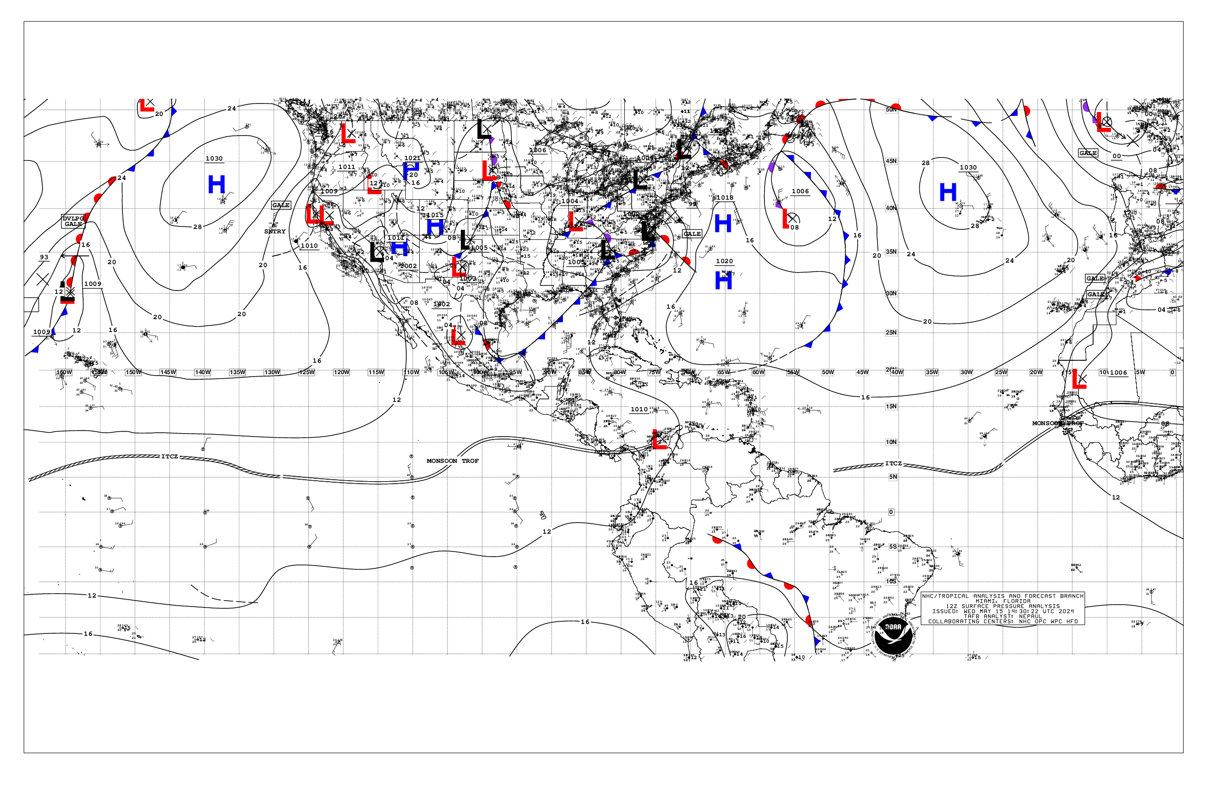
000
AXNT20 KNHC 161752
TWDAT

Tropical Weather Discussion
NWS National Hurricane Center Miami FL
1805 UTC Thu May 16 2024

Tropical Weather Discussion for North America, Central America
Gulf of Mexico, Caribbean Sea, northern sections of South
America, and Atlantic Ocean to the African coast from the
Equator to 31N. The following information is based on satellite
imagery, weather observations, radar and meteorological analysis.

Based on 1200 UTC surface analysis and satellite imagery through
1730 UTC.

...SPECIAL FEATURES...

...GALE-FORCE WIND WARNING IN THE METEO-FRANCE AGADIR MARINE
ZONE...

The current METEO-FRANCE forecast consists of gale-force winds,
and rough seas, for the marine zone AGADIR, from 16/1200 UTC
until 16/2100 UTC. Please, read the latest High Seas Forecast,
that is issued by the METEO-FRANCE, at https://wwmiws.wmo.int,
for details.

...MONSOON TROUGH/ITCZ...

The monsoon trough passes through the coastal plains of Guinea
near 10N14W, to 07N22W. The ITCZ continues from 07N22W, to 04N30W
and 01N38W. Precipitation: no significant organized deep
convective precipitation is in the area.

Scattered moderate to isolated strong is from 16W eastward. This
precipitation is on the northern side of an upper level east-to-
west oriented trough.

Areas of rainshowers are from 10N southward between 40W and 60W.
The precipitation is close to an upper level NW-to-SE oriented
trough.

...GULF OF MEXICO...

A western Atlantic Ocean cold front is reaching the Florida east
close to 28N. The front is stationary from 80W to 86W along
27N/28N. The front is warm from 27N86W, to the Texas coast close
to 29N96W. Rainshowers are from the warm front northward from 90W
westward, and within 60 nm to the south of the frontal boundary
from 86W eastward.

Moderate seas are in the NW quadrant of the Gulf of Mexico, and in
parts of the east central Gulf. Slight seas are elsewhere. Mostly
fresh to some strong southerly winds are from 25N southward
between 85W and 95W. Moderate or slower winds are elsewhere.

A NW-to-SE oriented inland Mexico surface trough passes through
24N100W, to the coastal waters of the northern side of the Isthmus
of Tehuantepec of southern Mexico, to north central Honduras. No
significant deep convective precipitation is apparent in the
satellite imagery.

A stationary front extends from Tampa Bay, Florida to 27N88W,
where it transitions to a warm front to the central Texas coast.
Showers and thunderstorms are expected to continue across portions
of the eastern Gulf through this morning along the front. The
warm front will continue lifting northward today, then stall
tonight into Fri along the northern Gulf coast. This will shift
the focus of heavy rain and thunderstorms to the northern Gulf
today through the weekend. Elsewhere, moderate to fresh return
flow will dominate the basin, pulsing to locally strong near the
Yucatan Peninsula and the Bay of Campeche. Winds will slightly
weaken Sun into early next week as the gradient relaxes.
Meanwhile, areas of haze and smoke due to agricultural fires in
Mexico continues across most of the western Gulf and Bay of
Campeche.

...CARIBBEAN SEA...

High pressure north of the basin is supporting fresh to strong
easterly winds offshore of central and eastern Honduras, as well
as in the south- central Caribbean, including portions of the Gulf
of Venezuela. Mainly moderate E to SE winds prevail across the
remainder of the basin, except light and variable in the southwest
Caribbean south of 12N. Seas are in the 3-4 ft range east of 70W,
and in the 5-8 ft range west of 70W. Isolated moderate convection
is noted in the southwest Caribbean south of 12N.

Fresh to strong SE winds, and moderate to rough seas, have been
in the NW corner of the area from 83W westward. Fresh NE winds
are from 11N to 16N from 75W westward. Fresh easterly winds are
within 150 nm of the coasts of Venezuela and Colombia between 65W
and 71W. Broad moderate anticyclonic winds are in the rest of the
Caribbean Sea. Slight seas are in the eastern one-third of the
area, and in the SW corner of the area. Moderate seas are
elsewhere.

The monsoon trough passes through 11N72W in northern Colombia,
through SE Nicaragua, beyond El Salvador, and into the Pacific
Ocean. Precipitation: scattered to numerous strong is within 120
nm to the north of the monsoon trough between 81W in the water and
85W inland in central Nicaragua; and from 10N to 12N between 79W
and 81W.

The gradient related to high pressure north of the area is
supporting fresh to strong winds in the Gulf of Honduras and in
the south central Caribbean. The strong winds in the Gulf of
Honduras will persist through Sun, reaching near gale-force speeds
Fri evening into Sat morning. Fresh to strong winds will pulse at
night in the Gulf of Venezuela and offshore Colombia through Sun
evening. Moderate to rough seas are expected with these winds.
Gentle to moderate winds are expected elsewhere through early next
week. Meanwhile, haze due to agricultural fires in Central
America continues across areas in the northwestern Caribbean.

...ATLANTIC OCEAN...

Please, refer to the SPECIAL FEATURES section, for details about
the gale-force wind forecast for the AGADIR marine zone.

A western Atlantic Ocean cold front passes through 31N75W, to
the Florida east close to 28N. The front is stationary from 80W to
86W along 27N/28N. Precipitation: scattered moderate to strong is
from 150 nm to 350 nm to the southeast of the cold front. The
24-hour rainfall totals in inches, for the period that ended at
16/1200 UTC, are: 1.63 in Freeport in the Bahamas, and 0.08 in
Bermuda. This information is from the Pan American Temperature
and Precipitation Tables/MIATPTPAN.

A surface ridge is along 15N46W 24N35W 31N30W. An upper level
trough is generating cyclonic wind flow that is from 20N northward
between Africa and 40W. Precipitation: scattered moderate is from
26N northward between 20W and 40W.

A stationary front is from 31N45W to 25N50W. A surface trough
continues from 25N50W, to 21N59W, through the NE corner of the
Caribbean Sea, to 13N64W. Precipitation: rainshowers are possible
within 270 nm on either side of the cold front/surface trough.

Moderate seas cover nearly the rest of the entire Atlantic Ocean.
An exception is for slight seas between 60W and 70W, and from 26N
southward from 70W westward. Moderate to fresh southerly winds are
from 70W westward. Fresh NE winds are: elsewhere from 27N
northward from 17W eastward; and from 05N to 15N between 35W and
60W. Moderate or slower winds are in the rest of the Atlantic
Ocean.

A stationary front extends from 31N79W southwestward to inland
Port Canaveral, Florida. Active weather in the form of numerous
thunderstorms are north of 25N and east of the front to near 69W.
Fresh to strong southerly winds accompanies the thunderstorms. The
cold front will reach from near 31N68W to 27N77W tonight and
weaken as it extends from 31N61W to 27N72W Sat morning. Fresh to
strong winds are forecast ahead of the front through Fri along
with showers and thunderstorms. Conditions will improve Fri night
into Sat as the front dissipates. Moderate to locally fresh winds
and moderate seas are expected through Sun.

$$
mt/ja
Alternate Formats
About Alternates -
E-Mail Advisories -
RSS Feeds
Cyclone Forecasts
Latest Advisory -
Past Advisories -
About Advisories
Marine Forecasts
Latest Products -
About Marine Products
Tools & Data
Satellite Imagery -
US Weather Radar -
Aircraft Recon -
Local Data Archive -
Forecast Verification -
Deadliest/Costliest/Most Intense
Learn About Hurricanes
Storm Names
Wind Scale -
Prepare -
Climatology -
NHC Glossary -
NHC Acronyms -
Frequently Asked Questions -
AOML Hurricane-Research Division
About Us
About NHC -
Mission/Vision -
Other NCEP Centers -
NHC Staff -
Visitor Information -
NHC Library
NOAA/
National Weather Service
National Centers for Environmental Prediction
National Hurricane Center
11691 SW 17th Street
Miami, Florida, 33165-2149 USA
nhcwebmaster@noaa.gov
Disclaimer
Privacy Policy
Credits
About Us
Glossary
Career Opportunities
Page last modified: Thursday, 16-May-2024 17:53:04 UTC